![]()
![]()
![]()
![]()
![]()
![]()
![]()
![]()
![]()
![]()
| Peltier Lake, Great Blue Heron and Other Environmental Information | ||
03/13/25 |
|
|
Welcome!This site provides information on Peltier Lake, the Great Blue Herons by Peltier Lake, the Chain of Lakes in Lino Lakes, and other environmental information. Peltier Lake is located in Anoka county in the cities of Lino Lakes and Centerville, Minnesota, about 15 miles north of Saint Paul. This site is maintained by Wayne LeBlanc. He does volunteer lake sampling for the Rice Creek Watershed District, MPCA, and the Sentinel Lakes Program. He monitors streams with the Stream Health Evaluation Project, has over 30 years of experience with lake issues, and helps monitor the Great Blue Herons. He has completed the Minnesota Master Naturalist Volunteer program.
Peltier Lake Heron Report, Feb 26, 2025
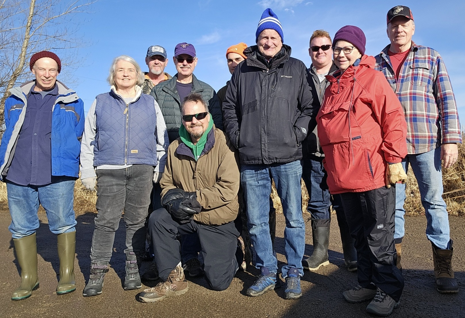
The new Lino Lakes Environmental Coordinator, Thomas Hoffman, organized
this year’s protection and survey effort for the Great Blue Herons and
Great Egrets of Peltier Lake Island, rounding up 10 volunteers to count
nests, and inspect and manage protective metal flashing on the trees.
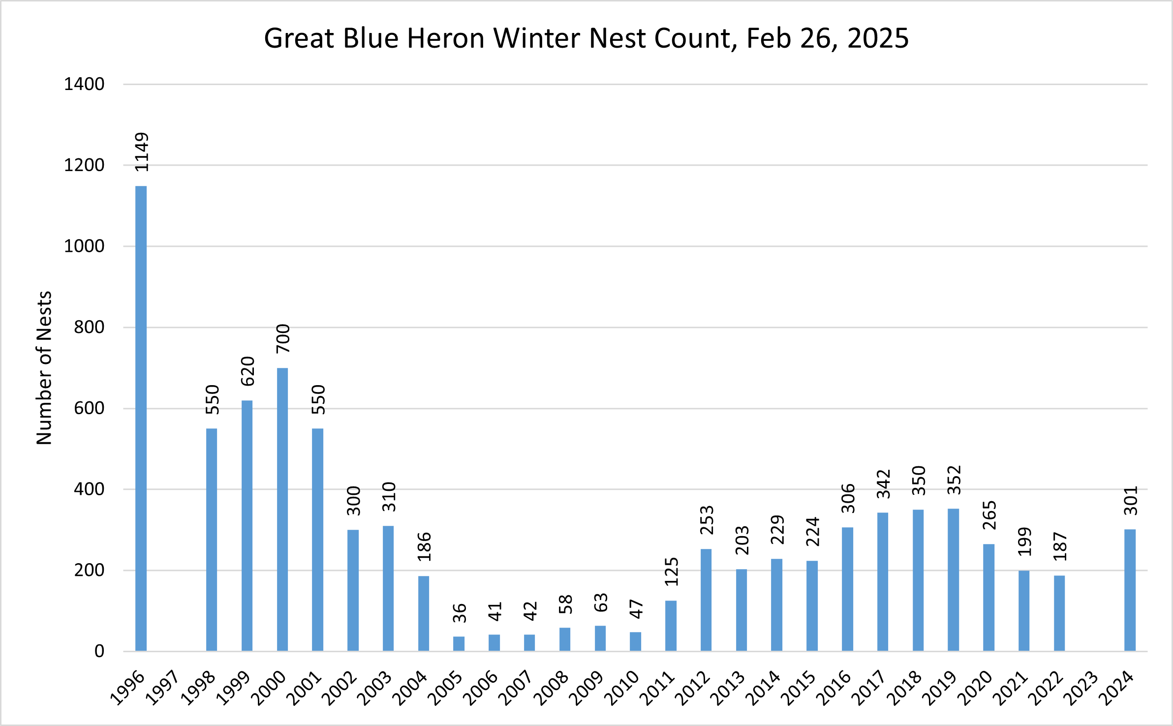
Wayne LeBlanc, Teresa O’Connell, Russ Birkholz, John Morrison, Kevin Fitzpatrick, Tom Hoffman, Marty Asleson, Quinn Palar, Barbara Bor, John Sullivan There are often Great Egrets that nest with the Great Blue Herons and the nests look the same, so they are not distinguished in the count or in the chart. For the summer of 2023, ice conditions were unstable most of the winter and a count was not attempted. The nest count, taken Feb 26, 2025, reflects the summer of 2024 and that count increased from roughly 200 to 301. There were about 40 additional smaller sized or incomplete nests that are not counted in the chart below. Before trouble, the count had been as high as 1,149. It would be nice to get closer to this number as the island looks like it has plenty of habitat for further expansion of the colony. John Sullivan, Teresa, Marty, Barbara, and Wayne conducted the nest count.
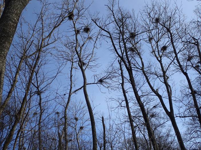
Many of the nesting trees are ash trees and it looks like the Emerald Ash Borer has killed most of them. Ash trees are not known to stand very long after dying. There is an effort to plant more trees on the island but with dry summers, survival of the new trees can be tough. In 2023, 82% of nests (153) were in ash trees and 65% of nesting trees (40) were ash. The total number of nests was 187 and total number of nesting trees was 62. In addition, tight flashing may be causing damage to the trees. Flashing was loosened to allow more air flow and flashing was removed from trees without nests. Flashing on ash trees may not matter as they are not expected to survive EAB. The Rotary Club and others have planted trees in anticipation of ash tree decline. Tom, Russ, John Morrison, Kevin, and Quin worked on the metal tree flashing.
Three protections need to continue to encourage continued improvement for the Great Blue Heron colony:
Wayne LeBlanc “Rookery Blues,” Minnesota Conservation Volunteer: www.dnr.state.mn.us/volunteer/marapr04/rookery.html. *********************************************************************** Troubled Waters at Peltier Lake
Wikipedia describes the former pristine condition of the watershed before houses, farms, and roads. It certainly isn't that way anymore! "According to the Minnesota Historical Society, Rice Creek was named for Henry Mower Rice, one of the first pair of U.S. Senators sent to represent Minnesota upon its statehood, who acquired extensive lands near the lower course of the creek in 1849. Early surveys conducted by Joseph Nicollet record the name of Rice Creek as "Ottonwey River" or Atoonowe-ziibi in the Ojibwe language meaning "River for making Canoes." However, its Ojibwe language name has also been recorded as "Manominikan Sibi" or Manoominikaan-ziibi, meaning "river full of wild rice," which is known to have grown plentifully in the lakes of the watershed. Nicollet described the creek as: "At 2:45, as we left the islands behind, a rivulet about thirty feet wide entered the river from the left. Its shores are adorned with beautiful white lilies. Chagobay told me that it winds back to the vicinity of the Falls of the St. Croix River, being separated from the latter by only a short portage. Its course links several alkes, while irrigating a land abundant with wild rice where the Sioux gather their yearly provisions. The Sioux call it in their language Wild Rice River, and the Chippewa Manominikan Sibi, which means river where one reaps wild rice. "Manomin" (wild rice) was also the basis for the naming of the former Manomin County, which later was incorporated into Anoka County and ultimately became, in part, the city of Fridley, where the creek joins the Mississippi River." "Archaeological evidence exists that suggests ancestors of the Sioux hunted and fished in the vicinity of Bald Eagle Lake (approximately present-day White Bear Township) in the Rice Creek watershed, and had a summer village in the present-day city of Centerville as early as 2000 B.C."
|
This site was last updated 03/13/25